If you can't read this email in html format, please, click HERE - Version française

Satellite data dedicated to environment and climate: Digital twins ahead

Chaired by Laurent Boisnard, Sous-directeur adjoint, CNES and Christelle Loiselet, Expert engineer, BRGM

Beyond the outline of a very rich technological and applicative landscape from last year, the 2021 workshop will be the opportunity to address the emergence of digital twins, identified among the major trends of the coming decade.

Already set in the industrial landscape and coupled with simulation and continuous data assimilation to reproduce modeled objects as closely as possible, digital twins applied to the Earth system and standardization of satellite data could transform our capacities for analysis, prediction and anticipation for public decision-making.

This theme will be the guiding thread of the 2021 edition around the environment and climate, where ocean physics, forest fires, soil mapping and water management will be addressed. Intended to become a tool to help territories adapt to impacts of climate change, the Spatial Climate Observatory (SCO) will also be featured. Two projects will be presented with the study of urban heat islets and the safeguarding of rice fields in Vietnam. Officially launched in 2019 and mobilizing global expertise, the SCO keeps in line with the Paris international agreements and the 2030 Agenda for Sustainable Development.

Teratec Forum 
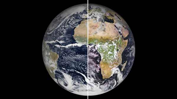
With 1 kilometer resolution, one European climate model (left) is almost is almost elusive compared to reality (right) © ECMWF © EUMETSAT

Industrialists and researchers will testify on the emergence of digital twins regarding the theme of environment and climate.

Laurent Boisnard

Introduction


Laurent Boisnard

Sous-directeur adjoint

CNES


Know more...


Christelle Loiselet


Christelle Loiselet

Expert engineer

BRGM


Know more...


The platform dedicated to Earth's twin


David Convers

Solution Developer & Analytics Product Owner, Airbus Defense & Space

CNES


Know more...


Frédéric Gille

Industry Business Consultant Senior

Dassault systèmes


Know more...


Spatial Climate Observatory: Thermocity, thermal imagery from space for metropolises


Vincent Lonjou

Chargé d’affaire

CNES


Know more...


Aurélie Michel

Ingénieure de recherche

ONERA


Know more...


Designing the future of wildfire modeling guided by high-resolution remote sensing data


Mélanie Rochoux

Chercheur Senior

Cerfacs


Know more...


Marielle Jappiot

Ingénieur de recherche

Inrae


Know more...


Automation of soil and water volume mapping by satellite -- AI4GEO-Mapping the future


Antoine Masse

Chef unité R&D

CLS


Know more...


Christophe Fatras

Ingénieur R&D

CLS


Know more...


Ronan Fablet

Blind men, pink elephants and digital twins of the ocean


Ronan Fablet

Professeur

IMT Atlantique


Know more...


Julien Le_Sommer

Julien Le Sommer

Chargé de recherche

CNRS / IGE


Know more...


Spatial Climate Observatory: VietsSCO, radar remote sensing monitoring of climate impacts on rice production in Vietnam


Thuy Le Toan

Senior researcher

Cesbio


Know more...


Stéphane Mermoz

CEO & Research Scientist

GlobEO


Know more...


Register now and get your badge by clicking here TERATEC Forum is strictly reserved for professionals. Participation to exhibition, conferences and workshops is free. It is mandatory to register online in advance. The badge is free of charge and give you access to all events TERATEC Forum.

+