 |
||
Home > TERATEC FORUM > Workshops > Workshop 4
Workshops
Wednesday June 23
Workshop 04 - 16:00 to 18:00
Satellite data dedicated to environment and climate: Digital twins ahead
Chaired by Laurent Boisnard, Sous-directeur adjoint, CNES and Christelle Loiselet, Ingénieure expert, BRGM
Monitoring by radar remote sensing of climate impacts on rice cultivation in Vietnam:
the VietSCO project
By Stéphane Mermoz, CEO & Research Scientist, GlobEO
and Thuy Le Toan, Senior researcher, Cesbio
 |
 |
The VietSCO-Rice project addresses climate change impacts on rice cultivation in Vietnam. In recent years, the increased frequency, duration, and intensity of droughts, floods, and salt intrusion pose a rising threat to the rice production in Vietnam, which plays a major role in the national economy. For adaptation measures, decision-making is currently based on data collected in situ at the local level (villages, provinces ...) and assembled in a database of national statistics.
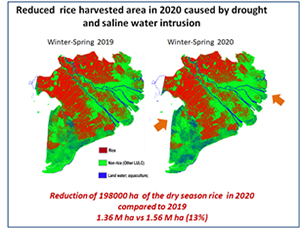
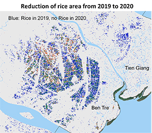
The project aims at providing a monitoring system based on Earth Observation for observing climate impacts on rice cultivation. Regularly acquired Sentinel-1 radar data (every 6 days, at 10 m resolution) are interpreted using dedicated methods and algorithms, to generate mapping information that supplements and/or replaces in situ data and statistics (area planted, state of development, cropping calendar, productivity indicators, number of harvests per year). The inter-annual changes observed since 2015, in particular in the Mekong delta, are analyzed according to variations in climatic indicators (drought, floods, salt intrusion, etc.), linked to anomalies observed in temperature, precipitation, etc., in particular in 2016 and 2020.
The project will provide free and open access to data and products that should allow, in the near term, to monitor the state of production and the forecast of the harvest. In the long term, the products will serve as a basis for climate mitigation measures (change in the rice calendar, reduction in the number of harvests per year, change in land use).
The big volume of data requires dedicated infrastructure. Currently, the processing chain includes automated steps (concerning the downloading of satellite data, preprocessing, and application of algorithms). Implementation of the developed system on the Vietnam Open DataCube has been considered, giving free access to the stakeholders.
 |
Biography: Dr. Thuy Le Toan is a senior researcher at the Centre d’Etudes Spatiales de la Biosphère. She is the PI of the ESA BIOMASS mission and Co-Lead of the Asia-Rice Initiative. Her interest is on the use of Earth Observation data to monitor land surface (vegetation, forest, agriculture) with focus on the impacts of climate change. |
 |
Biography: Dr. Stéphane Mermoz received the Ph.D. degree from the Universities of Rennes I and Quebec (Canada) in 2010. Since 2011, he has been a Research Fellow with the Centre d’Etudes Spatiales de la BIOsphère (CESBIO) where his interests include the use of remote sensing data, in particular SAR, to monitor vegetated areas for environmental applications. In 2018, he founded the company GlobEO and is pursuing his scientific research. He has been involved in more than 15 projects, funded by ESA, the European Commission and CNES. He has authored and co-authored more than 25 peer-reviewed scientific articles.
|
![]()
Register now and get your badge here
- TERATEC Forum is strictly reserved for professionals.
- Participation to exhibition, conferences and workshops is free (subject to seats available)
- On line registration is obligatory.
![]()