 |
||
Home > TERATEC FORUM > Workshops > Workshop 4
Workshops
Wednesday June 23
Workshop 04 - 16:00 to 18:00
Satellite data dedicated to environment and climate: Digital twins ahead
Automation of soil and water volume mapping by satellite - AI4GEO-Mapping the future
By Antoine Masse and Christophe Fatras, CLS
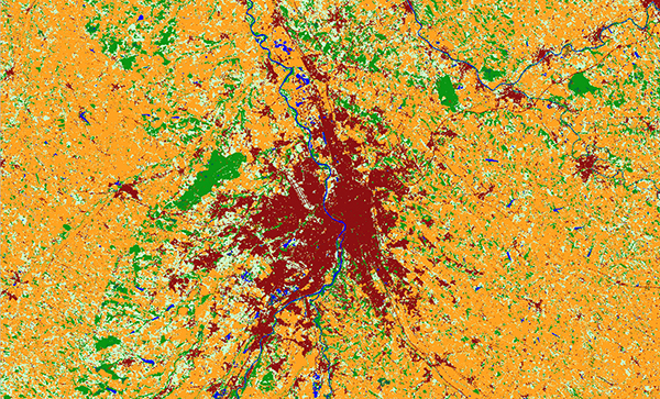 Carte d’occupation du sol sur Toulouse |
Abstract: The availability of 3D Geospatial information is a key issue for many expanding sectors such as autonomous vehicles, business intelligence, urban planning, and environmental applications. Its production is now possible thanks to the abundance of available data (e.g., Earth observation satellite constellations, in-situ data) but manual interventions are still needed to guarantee a high level of quality, which prevents mass production.
New artificial intelligence and big data technologies adapted to 3D imagery can help to remove these obstacles.
The AI4GEO project aims at developing an automatic solution for producing 3D geospatial information and new added-value services. Started at the end of 2019 for a 4-years duration the project timeframe is divided into 4 key stages (KS 1-4) and has already produced very promising results for KS1. This presentation will first introduce AI4GEO initiative, context, and overall objectives. It will then present the status of the project and focus on the environmental thematic. Spearheading the subject CLS has been carrying this field for decades and continues to innovate to bring about answers to societal questions. It will present the very first results of Land Cover innovations, water monitoring and associated perspectives. The mastery of satellite information and its understanding coupled with multiple in-situ datasets offer a complete analysis capacity adapted to the different demands and situations encountered e.g., territorial monitoring, emergency management, climate change monitoring.
 |
Biography: Dr. Antoine Masse is responsible of the Research and Development unit in the Land and Hydrology department at CLS since 2018. He previously worked as a PhD researcher and twice as a postdoctoral researcher for the Centre d’etudes spatiales de la biosphère (Cesbio), the Institut national de l’information géographique et forestière (IGN), and the Centre National d’Etudes Spatiales (CNES) respectively. These researches mainly focused on automation and optimization of image processing chain: land cover mapping, cartographic visualization, and image processing (Pléiades and Spot). |
|---|---|
 |
Biography: Dr. Christophe Fatras is a Space hydrology R&D engineer at CLS. After completing his PhD in space altimetry at CNES/ONERA/GET, he worked for two years in hydrology and glaciology from space remote sensing data in Ecuador, in particular for flood monitoring purposes. After a year at CESBIO laboratory working on the hydrology of the Congo Basin from SMOS data, he develops since 2019 innovative algorithms at CLS for flood monitoring and water surface detection from various remote sensing satellites. |
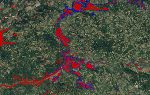 Inondations dans les LANDES en 2019 |
![]()
Register now and get your badge here
- TERATEC Forum is strictly reserved for professionals.
- Participation to exhibition, conferences and workshops is free
- On line registration is obligatory.
![]()