 |
||
Home > TERATEC FORUM > Workshops > Workshop 1
Wednesday October 14, 2020 - Workshops
Workshop 01 - 09:00 to 10:30
Environment and satellite data: from abundance of applications to the surge of structured solutions
Chaired by Laurent Boisnard, Deputy Head of Earth Observation, CNES and
François Robida, BRGM
Deep learning on remote sensing images:
a new era for environmental applications
|
|---|
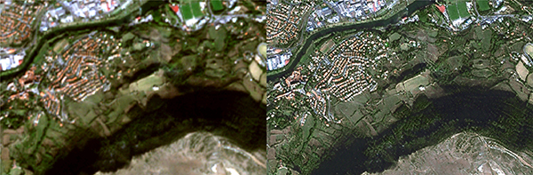
 Land cover map of man made structures Land cover map of man made structuresCopyright INRAE / UMR TETIS - All rights reserved |
The volume of earth observation data is constantly growing. In one hand, the volume of satellite imagery is increasing each year, thanks to a growing number of sensors in constellations delivering continuous acquisitions. On the other hand, information systems deliver a flow of geographical data resulting from open data policies and the emergence of community-based geographic information systems. In recent years, deep learning has impacted many fields for the analysis of very large volumes of data. With large available data volumes, and thanks to deep learning, remote sensing benefits from new approaches that supplant previous generations of algorithms in terms of versatility, performance and scalability. |
A large number of new environmental applications are emerging, in particular for monitoring resources and consumption of natural and agricultural areas. Among examples illustrating the versatility of deep learning applied to remote sensing, and foreshadowing tomorrow's applications for earth observation, the annual mapping of urbanization and artificialization over mainland France provides crucial information for managers.
Within the framework of the scientific expertise centre of the THEIA land data centre, thanks to new techniques and hardware architectures, open-source software, and from thousands of optical satellite images available each year, deep learning is applied to map human constructions at a resolution of 1.5m over the French territory.
 |
Biography : Rémi Cresson received the Electrical Engineering degree from the École Nationale Supérieure de l’Énergie, de l'Eau et de l'Environnement, Grenoble institute of technology in 2009. He is now with the French National Institute for Agricultural Research. As specialist in remote sensing and image processing, his research and engineering fields include geospatial images processing at scale, high performance computing, machine learning, and geospatial data interoperability. He is involved in open source software development, member of the Orfeo ToolBox Project Steering Committee and also member of the Open source geospatial foundation. |
|---|---|
 |
Biography : David Youssefi received the Electrical Engineering degree from the École Nationale Supérieure d’Electronique, Informatique, Télécommunications, Mathématique et Mécanique, Bordeaux, France. From 2013 to 2018, he was a Study Engineer at Communications et Systèmes, Toulouse, where he worked on remote sensing image processing especially in 3D processing. He is currently with the Centre National d’Etudes Spatiales (French Space Agency), Toulouse, as a Ground Segment Software Development Engineer where he is responsible for software development for Pleiades and design for the future Earth Observation mission CO3D from CNES. |
![]()
Register now and get your badge here
- TERATEC Forum is strictly reserved for professionals.
- Participation to exhibition, conferences and workshops is free (subject to seats available)
- On line registration is obligatory.
![]()
For any other information regarding the workshops, please contact :
Jean-Pascal JEGU
Tel : +33 (0)9 70 65 02 10
jean-pascal.jegu@teratec.fr
Campus TERATEC
2, rue de la Piquetterie
91680 BRUYERES-LE-CHATEL
France
![]()